Flying Missions in a remote desert: In search of our ancestral trails III


The tests on the second day of our mission turned out very successful. The aerial videos we obtain from the Autodesk Octo-copter were fabulous, capturing the splendid landscapes around the Turkwel Camp. More importantly, we understood how this machine could help us with field surveys on the ground: secrets of ancient remains are often disclosed from another perspective and our copter could certainly offer that.
As we all looked forward to the debut of our intelligent agent in the field, the night fell. Tied up to the logistics and power shortage, still not so much used to a shower of bugs and the penetrating heat even at night, we only had little sleep but had to get up at 5 in the morning, when it was still pitch dark. It was a race against the parching sun, one of the most hostile things in the desert. The golden time for any field operation in Turkana is either early in the morning or late in the afternoon. There is simply nothing we can do but rest in the middle of the day. Nobody would afford having a heat shock in the desert, neither would our gears.
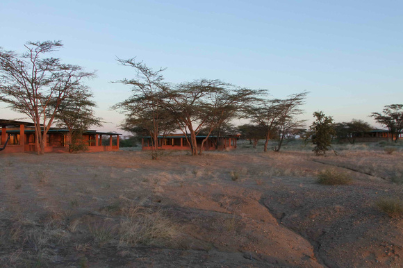
After a brief breakfast and check-ups of all apparatus, at the first light of dawn, we headed to Lothgam, a Miocene fossil site ~40 km to the southeast of TBI Turkwel Camp. It sounds not far away, but carrying a sophisticated machine with all kinds of electronic devices and on rough roads, we couldn’t go fast. Our field leader and driver Louise Leakey was well aware of that. The trip turned out a two hours’ drive and by the time we arrived, the sun was already well above the horizon.
Lothagam is known for the abundance of its paleontological evidence of the late Miocene period, about 5.5 to 8 million years ago. Thousands of fossils specimens have been uncovered in the last four decades. Having looked at some of the Lothagam materials myself, however, I never expected that this site could be so alien!
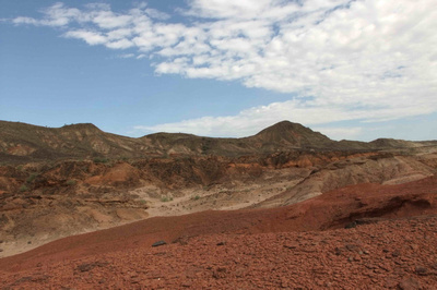
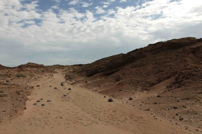
Reddish terrain dotted with black volcanic rocks, exposed and shaped by primeval forces. Some of the iron-rich sediments have been chiseled away, leaving winding gullies and gorges.
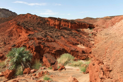
Looking at the martian landscapes of Lothagam, we felt as if we were standing on the surface of another planet. Only the blue sky, white clouds and a few green pioneers could give away our tie to mother Earth.
Animal remains in the sandstones tightened this connection even more. As we walked around, we found quite a few fossil fragments scattered on the surface of ancient sediments, preserved and revealed by the power of nature itself. For years, the land we walked on was submerged under the lake water, but now, the lake shore is far beyond our sight. A few million years, long enough to bear such dramatic changes, long enough to turn the alive into rocks, is only a blink of time in the geological history.
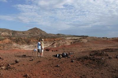
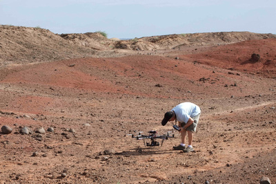
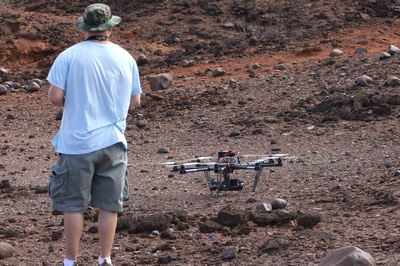
This time, however, we were not going to decipher the encrypted stories of the past. We were going to fly! Settled on top of a small hill, we put up all gears and prepared for our first flight. Our targets are the remains of human settlements: stone circles in various sizes, about 10,000 years old. Since we did not settle near the circles in the first place, our captain and pilot Gonzalo Martinez decided to fly with his virtual reality goggles and search for them from the sky! With the capability to cover a large area from high up, the copter is our airborne scout!
Under moderate wind, the copter took off following the directions given by our expedition leader Louise. It is very easy to lose orientation in a labyrinth like this, especially for recruits such as the rest of us. Her experience was vital for the whole crew to survive this hostile environment.
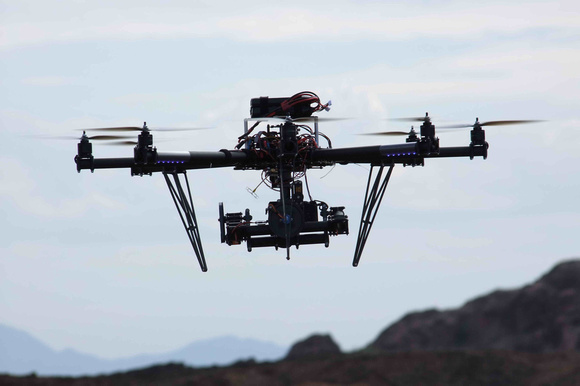
As the copter went far, we could only see it as a black dot moving in the blue backdrop. The sound of its motors was totally drowned by the blowing wind. After a few rounds searching, our captain Gonzalo spotted the stone circles from his goggles. The copter was right above the ancient structures! It was his first time to see archaeological remains from the air. With a Sony NEX-7 on board, we were all expecting the first aerial video ever recorded in this place.
However, when the copter was turning back, something unexpected happened. All of a sudden, the copter swung to the left as if dragged by an irresistible force. Directed by the steep slopes, the wind on the hillside formed a powerful turbulent, stroke the copter hard. The gale was so overwhelming that no matter how hard our captain pushed the joystick, the copter was still unable to fight against it. Just at the same moment, harsh beeps came out from the remote controller. WARNING! The copter was under low battery! If it failed to land in a few minutes, a crash would be inevitable! But the copter was still a few hundred meters away, struggling back against strong headwind. “We are going to lose it!” So did our captain say…
When all magic of our machine seemed to be gone, our captain activated an automatic mode. Carrying a GPS component, the copter records the coordinates when it takes off and can come back to the same place automatically. That makes the “flying spider” really intelligent, but it was certainly the last thing we wanted to do.
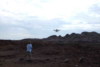
Acting all on its own wills, the copter started to climb and successfully got out of the turbulent. Slowly by slowly, the black dot grew bigger and bigger. Against all odds, it came back! Under manual control again, the copter finally landed in one piece!
After the last few minutes of the breathtaking flight, it was a huge relief for our captain Gonzalo to have the copter on the ground, safe and sound. Although the first field operation of our air force unite almost became its last, it showed its reliable strength and stamina. Kudos to the copter and the captain! (To be continued)
View and download photos of this post: Lothagam Landscapes; Flying missions
Aerial video by Gonzalo Martinez, taken from the copter.
Comments
Thank you so much for sharing your precious experiences in Lake Turkana with us, in your interesting and clear story-telling style.
Highest respect for your field work in Kenya!
Having the chance to touch the state-of-the-art technology in such a remote area is a huge privilege. It is so fascinating that how much new tech can do to help with the study of old stuff, such as fossils, artifacts and ancient remains. So I felt obligated to report our amazing experience in the field and bring this excitement to friends.
Thank you again for your highest praise. It's my greatest honor to have your personal concern.
In all seriousness, I ought to assign this as required reading for PKU students, to show what is possible through commitment to excellence in scientific communication.
What more might be said? I salute you and your colleagues for carrying out such intelligent, pathbreaking research around Lake Turkana.
You're doing an immense public service, Deming, by writing such detailed descriptions with attractive photographs.
Next to you, I'm only an amateur, trying to master basic camera settings, while your efforts are directly advancing scientific understanding.
Thank you so much for your work to bring this project to life for those of us far removed from northwestern Kenya.